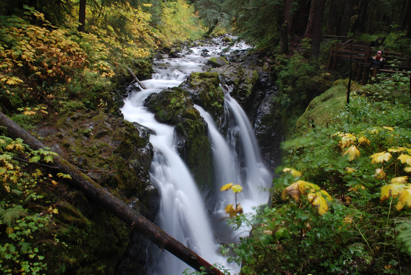
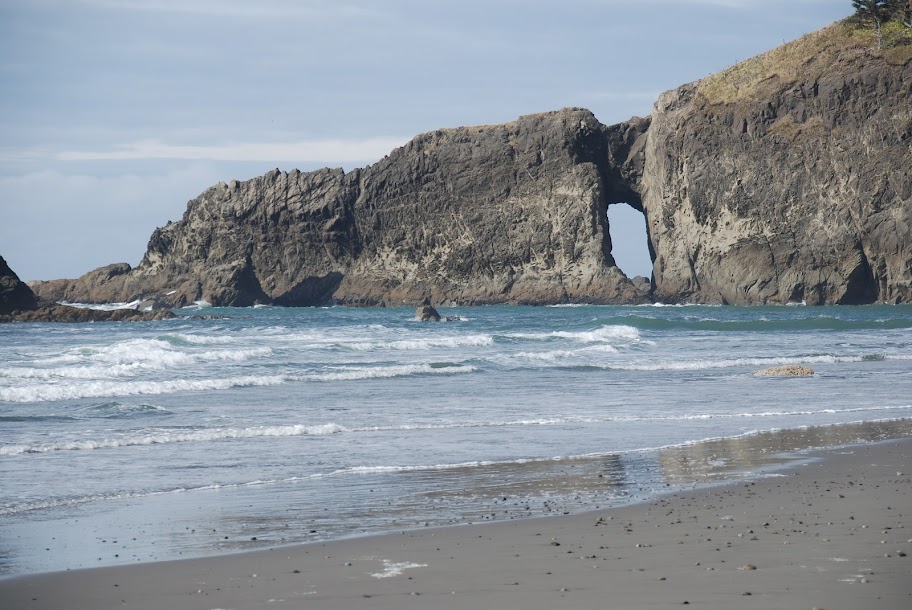
| People continued to populate the region through the end of the last ice age as the glacial ice retreated and the sea level rose. They, as well as the people who came after, are the ancestors of the current tribal groups that also lived in the area when the first European explorers sailed along the coast. The coastal tribes had a unique way of life, and even though there were some differences between each tribe, they held much in common. Unlike inland tribes, the life of the coastal peoples was relatively easy, and water travel made trade efficient and easy. Food more or less came to them, and it was always available. They fished for salmon, cod, and other fish and cured them in the wind. The tribes on the west side of the Peninsula hunted for whales in dugout canoes carved from the largest cedar trees. They hunted deer, otter, and elk and dried the meat, and cured the skins, and used the bones for spear points and tools. Floats used in whaling were made from the skins of seals and sea lions. Shellfish were easily harvested by walking along the beach to pick up or dig for clams, oysters, mussels, shrimp, and crab. They also harvested berries, plant roots, and seaweed. They did not need to stray far from the shores, and myths tell of monsters and a mysterious and violent tribe of people who lived in the interior. Since they did not have to move constantly in search of food, and since the weather throughout the region is so moderate, the tribes were able to establish permanent villages with large, communal long houses made of cedar slabs. Some, such as Old Man House of the Suquamish, grew to be 900 feet long and 60 feet wide. Family groups erected woven cedar screens for privacy. The soft, inner layer of cedar bark was also used to make baskets, hats, and clothing that was sometimes lined with the hair of white dogs that were specially bred for their soft, fluffy, woolly fur. In the warmer summer months, some tribe members traveled to summer camps in prime fishing areas where, for as long as the fish ran strong, they would camp, rising each morning to string nets across the rivers or to set out in canoes with fishing lines spun from nettle fiber. The fish were then cleaned and butterflied and either smoked or set on frames to bake in the sun and wind until they were dried and preserved. When the fall rains moved in, the summer encampment was disbanded, and the people returned to their winter villages. It was through the long, dark, wet winter that the oral tradition was passed on to the next generation through stories, myths, and rituals. Artists carved and painted paddles, dishes, ceremonial masks, and clan totems, and others wove baskets and made new clothes. The Native Americans of the Pacific Northwest Coast developed a rich and varied culture due in part to the long winters when these common activities were refined into high art among the nobility of the tribes. Among most area tribes a strict social hierarchy separated the people into three classes: nobility, commoners, and slaves. Chiefs, high and low, came from the nobility, and nobles married nobles, and only rarely did a commoner increase his or her rank by adoption by or marriage to a member of the nobility. Intermarriage among the tribes was common. The ruling class had more material goods, owned slaves, and held the allegiance of the commoners in a house and village. They had more leisure time to engage in artistic pursuits, although they were still expected to do their parts in feeding and especially protecting their village. The nobility also had certain rights such as the rights to the exclusive use of certain clan symbols and dances, the rights to fish on certain streams or in a particular bay, or the right to certain names. In most areas there was little difference between commoners and slaves except that commoners were born into the tribe and were more independent in choosing their activities and mates. The potlatch was one of the most important social and political occasions. To hold a potlatch, a chief or other high-ranking person would invite chiefs and other members of surrounding villages to the event. The entire village would prepare for the potlatch over months. Villagers would work weaving baskets, carving paddles, preserving and preparing food, and making gifts for guests to prepare for the potlatch. The greatest gifts were given to the highest ranking or most important guests. Sometimes, the people giving potlatches gave away nearly everything they owned. In turn, they would be invited to future potlatches given by others. It was in this way that people showed their status and preserved or increased their rank in the social order. The potlatches also gave tribes a chance to socialize, network, and set up new alliances. Sometimes guests helped to erect corner poles and long houses. Potlatch gatherings could last for weeks as those invited traveled to the area and assembled before the feast. The feast was the crowning event with singing, ceremonial dancing, and of course, the distribution of gifts. The feast was when the guests witnessed the wealth and rank of their host. Potlatches could be described as a combination between a caucus and a festival. When a chief needed more slaves, he launched a raid against surrounding tribes. Some slaves were the spoils of wars. In fact, the Quileute, who myths say descended from wolves, used James Island as a sort of defensive fortress. At one time, James Island was connected to the mainland by a tiny isthmus, much like the bridge across a mote. The Makahs, a tribe that lives by Cape Flattery in Neah Bay, would launch raids upon the Quileute. When the raiders were spotted, the entire village would move onto the island where they would boil water in tightly woven baskets and then pour the water on the raiding warriors in their canoes at the base of the island. The island was also used as a burial ground for the chiefs, and the tribe grew nettles there as well. North of James Island, and a few miles south of Cape Flattery, the Ozette established a village on Cape Alava. More than 800 years ago, that village was destroyed–smothered by a mudslide. The mud perfectly preserved the intact village until rain and time washed the silt away and revealed the site to a passing hiker. Archeologists excavated the village in the 1970s, and most of the artifacts are now housed in the Makah Cultural and Research Center. Those and other artifacts from sites around the two peninsulas tell us much about how the first peoples of this land lived. Tribes on the Olympic Peninsula are often grouped with the Coastal Salish peoples. However, the Quileute seem to be unrelated, linguistically at least, to any other population in the world. The Quileute were linked through their unique language to the Hoh and the Chimakum, who, according to legend, were washed through the strait to the northeast corner of the Peninsula. Other tribes on the west side of the Peninsula include the Quinault with villages at Queets and Tahola as well as the Makah and Ozette. The Klallam territory extended from Port Townsend to Sekiu, and the tribe traded with the Indians on Vancouver Island as well as those on the Peninsula. The Twana, which included the Skokomish and Quilcene bands, occupied the shores of Hood Canal. The Suquamish lived on the east side of the Kitsap Peninsula, and the Chehalis lived around Grays Harbor. These first peoples lived in harmony with the land for centuries, fishing, hunting whale, gathering wild fruits and vegetables, weaving, creating great works of art, and occasionally engaging in war and raiding for slaves. In 1592, approximately 100 years after the landslide at Ozette, Juan de Fuca, a Greek sailor sailing for Spain, claimed to have found the entrance to the mythical Northwest Passage. Although many doubt the veracity of that claim, the Strait of Juan de Fuca is nevertheless named after the explorer. The first recorded contact between the European explorers and the people of the Peninsula came in 1775 when members of Juan Francisco de la Bodega y Quadra's crew–another Spanish exploration party–made landfall near the Hoh River. All six men in the landing party were killed on the beach by members of the Quinault tribe. The first English explorer to visit the region was Captain James Cook, who explored the coast in search of the Northwest Passage. Cook charted and named Cape Flattery, and although he did not know it, his two ships, Resolution and Discovery, crossed briefly into the waters of the Strait of Juan de Fuca. George Vancouver, a man who later explored the area was a member of Cook's crew. No other European explorers visited the area for seven years before the flurry of fur traders came to the area and traded trinkets for sea otter skins. One of these traders, Captain Charles William Barkley, recognized the strait for what it was and named it for Juan de Fuca when he charted it. John Meares, another English trader accompanied by Captain William Douglas, named Mount Olympus and had a rather surly encounter with the Makah wherein four of his crew were wounded and one Makah was killed. Shortly afterwards, the Spanish established a short-lived fort at Neah Bay. After only five months of occupation, one Spaniard was dead, and the Makah were on the verge of declaring war upon them, the Spanish abandoned the post. The first American to explore the coast was yet another fur trader, Captain Robert Gray. He first came with John Kendrick in 1788. Gray sailed on the Lady Washington and Kendrick captained the Columbia Rediviva. On his first trip, he bought otter skins on the coast and then sailed around the world on his way back to Boston. Gray returned in 1792 aboard the Columbia Rediviva for more furs. On that trip he discovered two important bodies of water. To the south he discovered the Columbia River, which he named after his ship. He also sailed into a deepwater bay that measures 12 miles wide by 17 miles long and encompasses 200 square miles. He named the harbor after himself, Grays Harbor. Before he charted both discoveries, Robert Gray met Captain George Vancouver, aboard a second ship named Discovery; he was on a military mission for England. It was Vancouver who named Puget Sound after one of his officers, Peter Puget, who was in charge of the team that explored the sound's southern reaches. Vancouver and his crew also charted much of the sound, including the Hood Canal. None of the Peninsula's interior was explored until after the arrival of American settlers. Even then, the early settlers only explored as far as they needed for establishing homesteads. Then in 1889, prompted by a comment made by the governor of the soon-to-be-state, the Seattle Press sponsored a team of would-be explorers who were charged with crossing the interior of the Olympic Mountains. A six-man team assembled by a foolhardy Scottish explorer named James Helbold Christie left Port Angeles in December of that year. Christie wanted to make a name for himself, and he knew if he waited to make the crossing until spring that he would be competing against a bevy of similar teams. The men of the Press Expedition carried 1,500 pounds of provisions and were accompanied by four dogs. The first two mistakes came in quick succession. The team rented a wagon to carry lumber to the Elwha River. The wagon couldn't make it through the think undergrowth to the river, and so the men bought two mules named Dolly and Jenny and cut a trail to the river. Cutting the trail took two weeks. Once there, they set about building a boat. That fiasco would lead one to believe that none of the men had ever built a boat–or perhaps it was that they drank the trip's allotment of whiskey. Once the boat was built and launched, it sank. The men dredged it out, dried it out, and spent two more weeks rebuilding it. When they launched it for the second time, it wouldn't go. Or rather, the only way they could get it to go was to pull it by man or mule power. By January 24, more than a month into the trip, they were only five miles up the river. They abandoned the boat. The rest of the trip was plagued by even more problems, including a blizzard that hit just after they abandoned the boat. They hauled heavy packs through thick snow and their poor mules, which were ill equipped for walking through snow, were cut and scraped by the sharp crust of ice. By early March, they were not even out of the Elwha watershed when Jenny the mule fell over a 400-foot ledge and had to be shot. They reapportioned her pack and set off again. A month and a half later, an injured Dolly laid down and would not get up. Christie unburdened her and set the starving mule free never to be seen again. They forged onward, only to encounter more problems when, a week later, the dogs ate the last of their meat. Luckily for the men, their dogs turned out to be good at harassing bears. After they shot their first bear, the men were so hungry that they melted and drank its fat. By this time it was May, and 20 days into the month they finally attained their destination, the other side of the mountains. They caught a boat from the Quinault Indian Reservation to Grays Harbor where they wired the Press to let them know they'd made it and to ask for money for haircuts and warm meals. Although the journey sounds more like a dark comedy than a glorious adventure, the men did chart some significant landmarks and named quite a few of the peaks in the Olympic range. You will have practically memorized the post-settlement history of the Olympic Peninsula if you remember these two things: timber and trains. Timber because it provided, and to a certain extent still does, the long-term economic base for the Peninsula, and trains because the railroad-that-never-was promised great riches and success. In April 1851, Alfred Augustus Plummer, a New England native enticed by tales of the region’s opportunities, landed in Port Townsend after he and his friend Charles Bacheldor paddled up Puget Sound from Steilacoom. The two promptly built a cabin on the beach and planted a garden. Shortly afterwards, they were joined by Loren Hastings and Francis Pettygrove–Pettygrove was cofounder of Portland, Oregon. The four agreed that it would be a good idea to found a town, and so Port Townsend was born. It was the first city on the Peninsula, and although its first enterprise, a fishery, failed, the city prospered thanks to the customs house and timber. By this time, trees were already being harvested to serve as ship masts. The super tall and extremely straight Douglas fir trees took weeks to harvest, but the need was so great that the effort was still profitable. It was so profitable in fact, that in order to ensure that trees were not illegally harvested from U.S. territory, a U.S. Customs office was established in what was to become Olympia. In 1853, the second customs officer, Isaac Ebey, petitioned the government to move the Port of Entry to Port Townsend, which had a deep, accessible, and safe harbor. The first ramshackle mills on the Peninsula were erected at Port Townsend and nearby Port Ludlow. Neither produced very much lumber, but the region’s output of finished lumber rose sharply when the Pope and Talbot company opened a steam mill on the northwest corner of the Kitsap Peninsula at Port Gamble. By the end of its first full year in operation, the mill had cut more than 3.5 million board feet. The company added more saws and production kept increasing. Under the leadership of Cyrus Walker, the company changed the way lumber and timber companies operated. The company built more mills, added more saws, bought land and held the living trees in reserve, stockpiled logs in log rafts for when times were tight, and bought a shipping company so it could transport its own lumber. By 1875 the company owned land throughout Puget Sound and was the largest landholder on the Peninsula and in the Washington Territory. While Pope and Talbot built mills on the Puget Sound, others built on-again off-again mills to the south around Shelton. It wasn't until the 1880s though that the mills there really took off, thanks in part to a railroad line that ran to Olympia. Although timber and lumber made Port Townsend, it was not because it produced the goods. They made Port Townsend because of the customs house. Any ship that left the region had to pass through customs at Port Townsend. The city turned into a boomtown as ship traffic increased. Merchants opened hotels, saloons, and stores to serve the sailors that passed through town. Some enterprising ladies even set up brothels. Shanghaiing–the practice of kidnapping men to fill a ship's crew–was common practice. Port Townsend was bigger than Seattad made the big time. Then came Victor Smith who, as customs collector, did his best to cut Port Townsend down. Smith just didn't like Port Townsend and persuaded the Secretary of the Treasury, Salmon P. Chase, to convince President Abraham Lincoln to move the port of entry west to Port Angeles and create a military reserve. Of course, wouldn't you know it, Smith had previously invested in real estate in Port Angeles, some of the very land that Lincoln established as the reserve. So in 1862, Smith bucked accusations of embezzlement and the protestations of Port Townsend residents and forcibly moved the customs house to Port Angeles. The disgruntled residents of Port Townsend sought revenge and justice and flooded President Lincoln with letters of complaint and affidavits of wrongdoing. Smith was fired, but appointed to the treasury department before he died a year later in a shipwreck. While the white people were battling over a customs house, the first peoples were meeting with government agents to sign treaties. On January 26, 1855, the Klallam, Chimakum, and Twana signed the Point No Point treaty. A few days prior, the Suquamish signed the Point Elliott Treaty, which restricted them to the Port Madison reservation. On January 31, the Makah and other tribes on the west end signed a treaty at Neah Bay. The treaties specified reservation boundaries and set down certain rules for the tribes such as the prohibitions against drinking alcohol and owning slaves. The treaties also set the "purchase price" of the former tribal lands. In most cases the fee paid to the tribes averaged around $60,000 for all of their lands, and in exchange they were given a reservation on their own lands. Even after the treaties were signed, the Americans managed to take away more land through set asides, which were later sold to whites. Such set asides drastically changed the Port Madison Reservation when prime waterfront parcels were sold to white people for summer homes. Tribal identity was further fractured when Native children were removed from the reservations and placed in boarding schools where they were forbidden to speak their own languages or to practice their own religions, rituals, and traditions. James G. Swan assisted with treaty negotiations between the coast tribes and Isaac Stevens, the territorial governor. Swan, who was originally from Boston, was a dabbler, and either a genius or a lunatic. He was a scientist, teacher, lawyer, author, artist, ethnographer, promoter, and historian. His diaries and books are still widely read. Swan happened to meet Chetzemoka, the Klallam chief from Port Townsend, in 1851 when the chief was visiting San Francisco while Swan was living there. The two became friends, and soon after the meeting Swan moved to the Willapa Bay area where he sold oysters by shipping them to California. While living on the coast he learned each tribe’s language as well as the trading jargon called Chinook. Swan was the customs collector on the coast from 1854 to until 1856, when he returned to the East Coast as Isaac Stevens’ assistant. He was back in Washington inside of two years when he settled in Port Townsend long enough to reacquaint himself with Chetzemoka before heading to Neah Bay where he tried and failed to run a trading post. Then he taught at Neah Bay for a few years before returning to Port Townsend in 1866, where he became one of the primary proponents for making Port Townsend the end of the railway line. In 1869, the transcontinental railroad crossed the continent. Peninsula residents, especially those in Port Townsend were ecstatic. They figured the city was the premiere candidate for the western terminus. After all, the customs house was in Port Townsend. Speculators gambled on the location of the railroad up and down the Peninsula. Cities along Hood Canal such as Union, Brinnon, and Quilcene started spending money, cutting lumber, and building like crazy. Unfortunately for the Peninsula, the terminus was granted to Tacoma in 1873. Hopes were raised again when city boosters organized the Port Townsend Southern Railroad in 1887. They laid one mile of track before the company went bust. In 1889 the Oregon Improvement Company, which was held by Union Pacific, said that it was going to build a line from Portland to Port Townsend. The company acquired the Southern line and extended the line to Quilcene, but building stopped in 1893 when the company failed. In 1893, the people of Port Angeles held out hope for a line from Everett to Port Angeles. They even had fundraising meetings, but the line never saw a single rail. Communities in the Grays Harbor area caught train fever when the Tacoma-Grays Harbor line was built. Several cities vied to be the western terminus, but Aberdeen won the bid when it built its own branch to meet the main line. By 1900, all hopes for the train-to-greatness were dashed before being briefly revived during World War I. The planes that flew in the war were made of spruce, and spruce grew on the Peninsula. However, the spruce wasn't all that accessible and so a special military division was established, the Spruce Production Division. The division was charged with logging the spruce through the winter, and then in the spring it was to begin work on a mill at Port Angeles and on the spruce railroad from there to the Neah Bay area. Two short lines were also built for mills near Quilcene and Pysht. The division only took six months to build the mill and the railroad, but peace had just been declared by the time they finished. The mill at Port Angeles changed hands a number of times until Rayonier bought it, and the railroad was eventually disassembled. Throughout the war and after, timber was logged at a feverish pace. The budding conservation movement expressed concern that all of the trees would be logged in short order if nothing was done to slow down the process. Thanks to the efforts of conservationists and three U.S. presidents, Olympic National Park was created. The 922,653-acre park started much larger, as the 2,188,800-acre Olympic Forest Reserve, set aside by President Grover Cleveland. Later, after being pared down by timber interests, part of what would become the park was set aside by President Theodore Roosevelt in 1909 as the Mt. Olympus National Monument, a preserve for the elk in the heart of their teeth for watch fobs decimated the elk. But the initial move to monument status still didn't protect the elk's winter habitat or many old growth timber stands that held some of the largest trees of their type in the world. President Franklin D. Roosevelt visited the monument in 1937 on a fact-finding mission and by the end of his visit he decided to add more property to the monument and make it Olympic National Park on June 29, 1938. Although the timber barons were less than thrilled that so many trees had been made inaccessible to them, they did not let that stop them from logging. In fact, the pace of harvest accelerated as new equipment became available to the loggers who started logging with axes then saws and used bull teams and then steam donkeys to pull the logs out of the woods. By the time log trucks and chainsaws were heard throughout the woods, much of the forest had already been logged once, and the loggers were now cutting into second growth as the trees were put to new uses. The logs were no longer just sold as raw lumber. Scientific and technological advances made it possible to use more trees in different ways. As Murray Morgan wrote in The Last Wilderness, "The research chemist was the fairy godfather who liberated the Cinderella tree [Western Hemlock] from the scullery. In 1909 the sulfate process was discovered for making newsprint out of wood. Hemlock wouldn't work at first, but scientists intensified their study of the structure of the tree. By the 1920s they had learned ways to take a hemlock apart and put some of together as paper or cellulose for scores of purposes." A similar discovery made plywood more useable, waterproof, and durable. Soon pulp and paper as well as plywood mills were scattered throughout the Peninsula. Logging peaked in the 1980s when timber companies raced to cut as many trees as possible before impending environmental legislation could take effect. New laws limiting where and what could be cut were enacted in order to preserve the few remaining stands of old growth trees and the plant and animal diversity of the Peninsula, and to protect the habitat of the tiny and reclusive northern spotted owl. Timber companies still push to cut as much as possible, and the old growth stands are still susceptible to the chainsaw, but tourist dollars have taken on a new importance to the region's economy, and communities that once relied upon timber have had to diversify in order to survive. Cities like Forks are trying to lure businesses by pushing the wired city concept with easy access to the Internet. The communities of the Olympic Peninsula are defined by their relationship to the oceans and the trees. No matter what the future brings, the people who live here will always rely in some part upon the land for their livelihoods. Even the tourists who come to the Peninsula visit to see the giant old growth trees dripping with moss and the broken peaks of the Olympic Mountains and the tumultuous waves on a stormy sea. When you visit the Peninsula, you cannot deny the land’s impact on our lives, nor the impact of our lives upon the land. Such is the history of the Peninsula from the time before memory. |
See Also:
| Olympic Peninsula | Map | Things to do | Landmarks | History | Useful Info | Weather |
You have read this article with the title
. You can bookmark this page URL http://oinsweden.blogspot.com/2012/02/history-of-olympic-peninsula-history-of.html. Thanks!
Write by:
AN - Wednesday, February 8, 2012


.jpg)


Comments " "
Post a Comment